🎉 Up to 70% Off Selected ItemsShop Sale
BG 006-Orobie - Val Serina
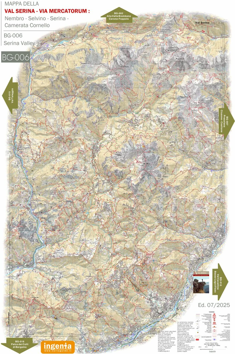
Mappa del settore centrale-inferiore delle Orobie Bergamasche. Oltre all'intera rete sentieristica aggiornata, la mappa evidenzia il percorso dell'antica "Via Mercatorum", un' antica rete di "mulattiere" percorsa dai "mercanti" che, con i loro muli, trasportavano le merci da Bergamo al nord Europa. La Via Mercatorum aveva inizio in Valle Seriana, raggiungeva l'altipiano di Selvino, proseguiva nelle due varianti (alta e bassa) verso il comune di Serina e poi scendeva a Cornello dei Tasso. Da qui ripartiva per l'Alta Valle Brembana, la Valtellina e la Svizzera. Oltre al alcune note località turistiche come Selvino e Serina, la mappa comprende anche due montagne molto frequentate dagli escursionisti: il Monte Alben e il Monte Arera.
La presenza di una fitta rete di sentieri e di mulattiere, in parte trasformate in strade sterrate, rende questo territorio un "paradiso" per i bikers anche se alcuni itinerari, per la loro difficoltà tecnica, non vanno sottovalutati.
Mappa stampata acquistabile su: https://www.ellelibri.com/
Map of the central-lower sector of the Bergamo Orobie. In addition to the entire updated trail network, the map highlights the route of the ancient "Via Mercatorum," an ancient network of mule tracks used by merchants who, with their mules, transported goods from Bergamo to northern Europe. The Via Mercatorum began in the Seriana Valley, reached the Selvino plateau, continued in two variants (high and low) towards the municipality of Serina, and then descended to Cornello dei Tasso. From there, it continued towards the Upper Brembana Valley, Valtellina, and Switzerland. In addition to some well-known tourist destinations such as Selvino and Serina, the map also includes two mountains popular with hikers: Monte Alben and Monte Arera.
The presence of a dense network of trails and mule tracks, some of which have been converted into dirt roads, makes this area a paradise for bikers, although some routes, due to their technical difficulty, should not be underestimated.
Product Information
Product Information
Shipping & Returns
Shipping & Returns


BG 006-Orobie - Val Serina
BG 006-Orobie - Val Serina
Mappa del settore centrale-inferiore delle Orobie Bergamasche. Oltre all'intera rete sentieristica aggiornata, la mappa evidenzia il percorso dell'antica "Via Mercatorum", un' antica rete di "mulattiere" percorsa dai "mercanti" che, con i loro muli, trasportavano le merci da Bergamo al nord Europa. La Via Mercatorum aveva inizio in Valle Seriana, raggiungeva l'altipiano di Selvino, proseguiva nelle due varianti (alta e bassa) verso il comune di Serina e poi scendeva a Cornello dei Tasso. Da qui ripartiva per l'Alta Valle Brembana, la Valtellina e la Svizzera. Oltre al alcune note località turistiche come Selvino e Serina, la mappa comprende anche due montagne molto frequentate dagli escursionisti: il Monte Alben e il Monte Arera.
La presenza di una fitta rete di sentieri e di mulattiere, in parte trasformate in strade sterrate, rende questo territorio un "paradiso" per i bikers anche se alcuni itinerari, per la loro difficoltà tecnica, non vanno sottovalutati.
Mappa stampata acquistabile su: https://www.ellelibri.com/
Map of the central-lower sector of the Bergamo Orobie. In addition to the entire updated trail network, the map highlights the route of the ancient "Via Mercatorum," an ancient network of mule tracks used by merchants who, with their mules, transported goods from Bergamo to northern Europe. The Via Mercatorum began in the Seriana Valley, reached the Selvino plateau, continued in two variants (high and low) towards the municipality of Serina, and then descended to Cornello dei Tasso. From there, it continued towards the Upper Brembana Valley, Valtellina, and Switzerland. In addition to some well-known tourist destinations such as Selvino and Serina, the map also includes two mountains popular with hikers: Monte Alben and Monte Arera.
The presence of a dense network of trails and mule tracks, some of which have been converted into dirt roads, makes this area a paradise for bikers, although some routes, due to their technical difficulty, should not be underestimated.
$9.99
BG 006-Orobie - Val Serina—
$9.99
Product Information
Product Information
Shipping & Returns
Shipping & Returns
Description
Mappa del settore centrale-inferiore delle Orobie Bergamasche. Oltre all'intera rete sentieristica aggiornata, la mappa evidenzia il percorso dell'antica "Via Mercatorum", un' antica rete di "mulattiere" percorsa dai "mercanti" che, con i loro muli, trasportavano le merci da Bergamo al nord Europa. La Via Mercatorum aveva inizio in Valle Seriana, raggiungeva l'altipiano di Selvino, proseguiva nelle due varianti (alta e bassa) verso il comune di Serina e poi scendeva a Cornello dei Tasso. Da qui ripartiva per l'Alta Valle Brembana, la Valtellina e la Svizzera. Oltre al alcune note località turistiche come Selvino e Serina, la mappa comprende anche due montagne molto frequentate dagli escursionisti: il Monte Alben e il Monte Arera.
La presenza di una fitta rete di sentieri e di mulattiere, in parte trasformate in strade sterrate, rende questo territorio un "paradiso" per i bikers anche se alcuni itinerari, per la loro difficoltà tecnica, non vanno sottovalutati.
Mappa stampata acquistabile su: https://www.ellelibri.com/
Map of the central-lower sector of the Bergamo Orobie. In addition to the entire updated trail network, the map highlights the route of the ancient "Via Mercatorum," an ancient network of mule tracks used by merchants who, with their mules, transported goods from Bergamo to northern Europe. The Via Mercatorum began in the Seriana Valley, reached the Selvino plateau, continued in two variants (high and low) towards the municipality of Serina, and then descended to Cornello dei Tasso. From there, it continued towards the Upper Brembana Valley, Valtellina, and Switzerland. In addition to some well-known tourist destinations such as Selvino and Serina, the map also includes two mountains popular with hikers: Monte Alben and Monte Arera.
The presence of a dense network of trails and mule tracks, some of which have been converted into dirt roads, makes this area a paradise for bikers, although some routes, due to their technical difficulty, should not be underestimated.