🎉 Up to 70% Off Selected ItemsShop Sale
El Yunque National Forest Visitor Map
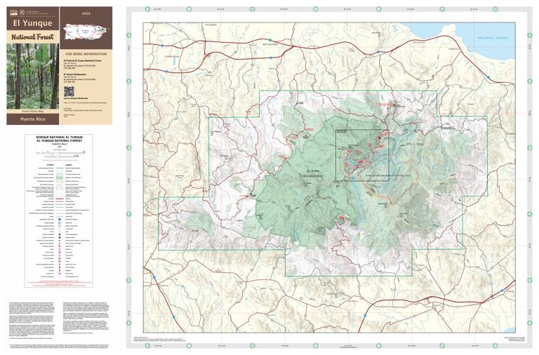
Welcome to the El Yunque National Forest! Located in Puerto Rico's Northeast Region, El Yunque National Forest is the only tropical rainforest within the national forest system. It extends through eight municipalities: Río Grande, Luquillo, Canóvanas, Fajardo, Naguabo, Ceiba, Las Piedras and Juncos. At nearly 29,000 acres, it is one of the smallest in size, yet one of the most biologically diverse. Come experience the breathtaking scenery, clear mountain rivers, and outdoor recreation opportunities year-round.
Forest Visitor Maps provide an overview of recreational opportunities including picnic areas, trailheads, waterfalls, and other points of interest. Geographic features and land ownership patterns are displayed at a scale convenient for use on a smart phone to keep you oriented to major landforms and help you plan your adventures.
National Forest System roads and trails are displayed and identified, although this map is NOT the official map designating roads and trails for MOTORIZED USE. For that purpose, please obtain a Motor Vehicle Use Map (MVUM). The MVUM is a legal enforceable document that shows the roads, trails, and areas designated for motor vehicle use. MVUM’s are reissued each year. It is the responsibility of motor vehicle users to acquire the current MVUM, available for free at https://www.fs.usda.gov/recreation/programs/ohv/ohv_maps.shtml. Geo-referenced versions of the current MVUM are also available at no cost on the Avenza Map Store as travel aids.
This product has an inset map included in the bundle for download.
Product Information
Product Information
Shipping & Returns
Shipping & Returns


El Yunque National Forest Visitor Map
El Yunque National Forest Visitor Map
Welcome to the El Yunque National Forest! Located in Puerto Rico's Northeast Region, El Yunque National Forest is the only tropical rainforest within the national forest system. It extends through eight municipalities: Río Grande, Luquillo, Canóvanas, Fajardo, Naguabo, Ceiba, Las Piedras and Juncos. At nearly 29,000 acres, it is one of the smallest in size, yet one of the most biologically diverse. Come experience the breathtaking scenery, clear mountain rivers, and outdoor recreation opportunities year-round.
Forest Visitor Maps provide an overview of recreational opportunities including picnic areas, trailheads, waterfalls, and other points of interest. Geographic features and land ownership patterns are displayed at a scale convenient for use on a smart phone to keep you oriented to major landforms and help you plan your adventures.
National Forest System roads and trails are displayed and identified, although this map is NOT the official map designating roads and trails for MOTORIZED USE. For that purpose, please obtain a Motor Vehicle Use Map (MVUM). The MVUM is a legal enforceable document that shows the roads, trails, and areas designated for motor vehicle use. MVUM’s are reissued each year. It is the responsibility of motor vehicle users to acquire the current MVUM, available for free at https://www.fs.usda.gov/recreation/programs/ohv/ohv_maps.shtml. Geo-referenced versions of the current MVUM are also available at no cost on the Avenza Map Store as travel aids.
This product has an inset map included in the bundle for download.
$4.99
El Yunque National Forest Visitor Map—
$4.99
Product Information
Product Information
Shipping & Returns
Shipping & Returns
Description
Welcome to the El Yunque National Forest! Located in Puerto Rico's Northeast Region, El Yunque National Forest is the only tropical rainforest within the national forest system. It extends through eight municipalities: Río Grande, Luquillo, Canóvanas, Fajardo, Naguabo, Ceiba, Las Piedras and Juncos. At nearly 29,000 acres, it is one of the smallest in size, yet one of the most biologically diverse. Come experience the breathtaking scenery, clear mountain rivers, and outdoor recreation opportunities year-round.
Forest Visitor Maps provide an overview of recreational opportunities including picnic areas, trailheads, waterfalls, and other points of interest. Geographic features and land ownership patterns are displayed at a scale convenient for use on a smart phone to keep you oriented to major landforms and help you plan your adventures.
National Forest System roads and trails are displayed and identified, although this map is NOT the official map designating roads and trails for MOTORIZED USE. For that purpose, please obtain a Motor Vehicle Use Map (MVUM). The MVUM is a legal enforceable document that shows the roads, trails, and areas designated for motor vehicle use. MVUM’s are reissued each year. It is the responsibility of motor vehicle users to acquire the current MVUM, available for free at https://www.fs.usda.gov/recreation/programs/ohv/ohv_maps.shtml. Geo-referenced versions of the current MVUM are also available at no cost on the Avenza Map Store as travel aids.
This product has an inset map included in the bundle for download.