🎉 Up to 70% Off Selected ItemsShop Sale
High Rock Canyon OHV Trails - Nevada
Rugged canyons, ancient lava flows, and raw high-desert solitude — this is one of Nevada’s wildest and most spectacular corners.
Location Humboldt, Pershing & Washoe Counties
Length 850 miles (Network)
Town Gerlach
Surface Dirt
Pets Permitted on Leash
Fees No
Wilderness Areas Black Rock Desert, Calico Mountains, East Fork High Rock Mountain, High Rock Canyon, High Rock Lake, Little High Rock Canyon, North Black Rock Range, Pahute Peak, Pine Forest Range
Wilderness Study Areas Lahontan Cutthroat Trout ISA, Wall Canyon WSA
Description
High Rock Canyon is a stunning Area of Critical Environmental Concern spanning over 46,000 acres of dramatic rock formations, deep canyons, and untouched wilderness. Located about 40 miles southeast of Cedarville, California, this remote landscape was shaped by tectonic forces and ancient lava flows nearly 17 million years ago.
The trails wind through breathtaking scenery with excellent opportunities for wildlife viewing, including bighorn sheep and nesting raptors. Historic archaeology sites are scattered throughout the canyons, and the dark night skies make it a paradise for stargazers. High-clearance 4WD vehicles are recommended for many routes, especially the rugged roads that climb into the heart of the canyon.
Other Information
• Motor vehicles permitted on designated routes only.
• High Rock Canyon Road is closed annually from early February until the second weekend in May to protect nesting raptors and bighorn sheep lambing.
• Camping is allowed only at designated sites: Red Bluff, Conlon, Pole Canyon, and Fox Homestead.
• Extremely remote — no reliable cell service. Bring extra spare tires, food, water, and recovery gear.
A wild and unforgettable high-desert adventure near the Black Rock Desert.
Product Information
Product Information
Shipping & Returns
Shipping & Returns


High Rock Canyon OHV Trails - Nevada
High Rock Canyon OHV Trails - Nevada
Rugged canyons, ancient lava flows, and raw high-desert solitude — this is one of Nevada’s wildest and most spectacular corners.
Location Humboldt, Pershing & Washoe Counties
Length 850 miles (Network)
Town Gerlach
Surface Dirt
Pets Permitted on Leash
Fees No
Wilderness Areas Black Rock Desert, Calico Mountains, East Fork High Rock Mountain, High Rock Canyon, High Rock Lake, Little High Rock Canyon, North Black Rock Range, Pahute Peak, Pine Forest Range
Wilderness Study Areas Lahontan Cutthroat Trout ISA, Wall Canyon WSA
Description
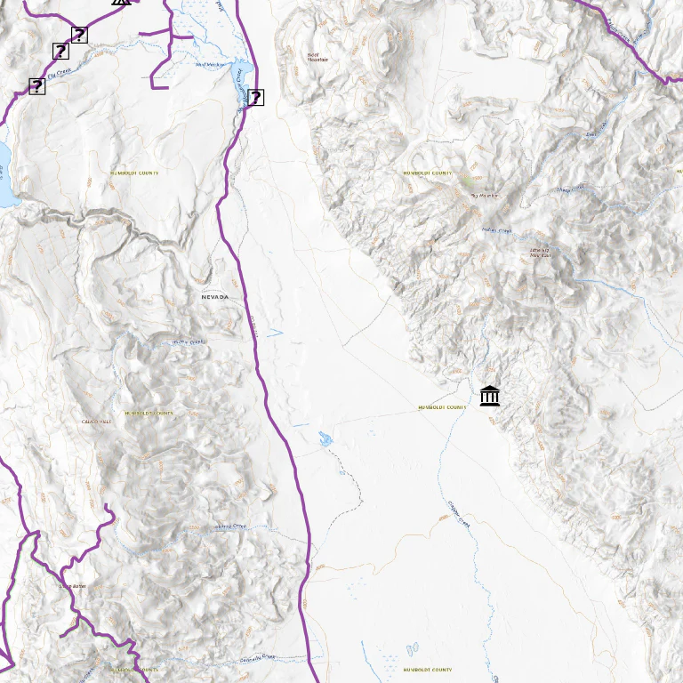
High Rock Canyon is a stunning Area of Critical Environmental Concern spanning over 46,000 acres of dramatic rock formations, deep canyons, and untouched wilderness. Located about 40 miles southeast of Cedarville, California, this remote landscape was shaped by tectonic forces and ancient lava flows nearly 17 million years ago.
The trails wind through breathtaking scenery with excellent opportunities for wildlife viewing, including bighorn sheep and nesting raptors. Historic archaeology sites are scattered throughout the canyons, and the dark night skies make it a paradise for stargazers. High-clearance 4WD vehicles are recommended for many routes, especially the rugged roads that climb into the heart of the canyon.
Other Information
• Motor vehicles permitted on designated routes only.
• High Rock Canyon Road is closed annually from early February until the second weekend in May to protect nesting raptors and bighorn sheep lambing.
• Camping is allowed only at designated sites: Red Bluff, Conlon, Pole Canyon, and Fox Homestead.
• Extremely remote — no reliable cell service. Bring extra spare tires, food, water, and recovery gear.
A wild and unforgettable high-desert adventure near the Black Rock Desert.
$1.99
High Rock Canyon OHV Trails - Nevada—
$1.99
Product Information
Product Information
Shipping & Returns
Shipping & Returns
Description
Rugged canyons, ancient lava flows, and raw high-desert solitude — this is one of Nevada’s wildest and most spectacular corners.
Location Humboldt, Pershing & Washoe Counties
Length 850 miles (Network)
Town Gerlach
Surface Dirt
Pets Permitted on Leash
Fees No
Wilderness Areas Black Rock Desert, Calico Mountains, East Fork High Rock Mountain, High Rock Canyon, High Rock Lake, Little High Rock Canyon, North Black Rock Range, Pahute Peak, Pine Forest Range
Wilderness Study Areas Lahontan Cutthroat Trout ISA, Wall Canyon WSA
Description
High Rock Canyon is a stunning Area of Critical Environmental Concern spanning over 46,000 acres of dramatic rock formations, deep canyons, and untouched wilderness. Located about 40 miles southeast of Cedarville, California, this remote landscape was shaped by tectonic forces and ancient lava flows nearly 17 million years ago.
The trails wind through breathtaking scenery with excellent opportunities for wildlife viewing, including bighorn sheep and nesting raptors. Historic archaeology sites are scattered throughout the canyons, and the dark night skies make it a paradise for stargazers. High-clearance 4WD vehicles are recommended for many routes, especially the rugged roads that climb into the heart of the canyon.
Other Information
• Motor vehicles permitted on designated routes only.
• High Rock Canyon Road is closed annually from early February until the second weekend in May to protect nesting raptors and bighorn sheep lambing.
• Camping is allowed only at designated sites: Red Bluff, Conlon, Pole Canyon, and Fox Homestead.
• Extremely remote — no reliable cell service. Bring extra spare tires, food, water, and recovery gear.
A wild and unforgettable high-desert adventure near the Black Rock Desert.