🎉 Up to 70% Off Selected ItemsShop Sale
Newport Oregon Offshore Fishing Map – Structure, Hotspots & Bottom Composition
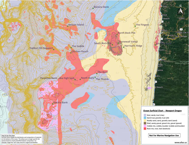
This high-resolution offshore fishing map for the Newport, Oregon area is built using advanced GIS analysis of NOAA bathymetry and surficial data to highlight key bottom composition and structure.
The map clearly identifies rocky vs. sandy bottom, allowing anglers to quickly target high-probability areas for lingcod, rockfish, and other bottomfish species. Steeper structure and reef zones are visually emphasized to help eliminate guesswork and reduce time spent searching.
In addition to bottom composition, this map includes labeled fishing locations and well-known offshore areas that have been compiled over years of on-the-water experience and research.
A detailed legend is included with guidance on how to interpret the data and apply it effectively while fishing.
Designed for use on mobile devices with apps such as Avenza Maps, this product provides a practical, data-driven approach to locating productive fishing grounds offshore Newport.
Product Information
Product Information
Shipping & Returns
Shipping & Returns


Newport Oregon Offshore Fishing Map – Structure, Hotspots & Bottom Composition
Newport Oregon Offshore Fishing Map – Structure, Hotspots & Bottom Composition
This high-resolution offshore fishing map for the Newport, Oregon area is built using advanced GIS analysis of NOAA bathymetry and surficial data to highlight key bottom composition and structure.
The map clearly identifies rocky vs. sandy bottom, allowing anglers to quickly target high-probability areas for lingcod, rockfish, and other bottomfish species. Steeper structure and reef zones are visually emphasized to help eliminate guesswork and reduce time spent searching.
In addition to bottom composition, this map includes labeled fishing locations and well-known offshore areas that have been compiled over years of on-the-water experience and research.
A detailed legend is included with guidance on how to interpret the data and apply it effectively while fishing.
Designed for use on mobile devices with apps such as Avenza Maps, this product provides a practical, data-driven approach to locating productive fishing grounds offshore Newport.
$14.99
Newport Oregon Offshore Fishing Map – Structure, Hotspots & Bottom Composition—
$14.99
Product Information
Product Information
Shipping & Returns
Shipping & Returns
Description
This high-resolution offshore fishing map for the Newport, Oregon area is built using advanced GIS analysis of NOAA bathymetry and surficial data to highlight key bottom composition and structure.
The map clearly identifies rocky vs. sandy bottom, allowing anglers to quickly target high-probability areas for lingcod, rockfish, and other bottomfish species. Steeper structure and reef zones are visually emphasized to help eliminate guesswork and reduce time spent searching.
In addition to bottom composition, this map includes labeled fishing locations and well-known offshore areas that have been compiled over years of on-the-water experience and research.
A detailed legend is included with guidance on how to interpret the data and apply it effectively while fishing.
Designed for use on mobile devices with apps such as Avenza Maps, this product provides a practical, data-driven approach to locating productive fishing grounds offshore Newport.