🎉 Up to 70% Off Selected ItemsShop Sale
Oregon SxS Trail Map 2510 C.G. south to Derrick Caves
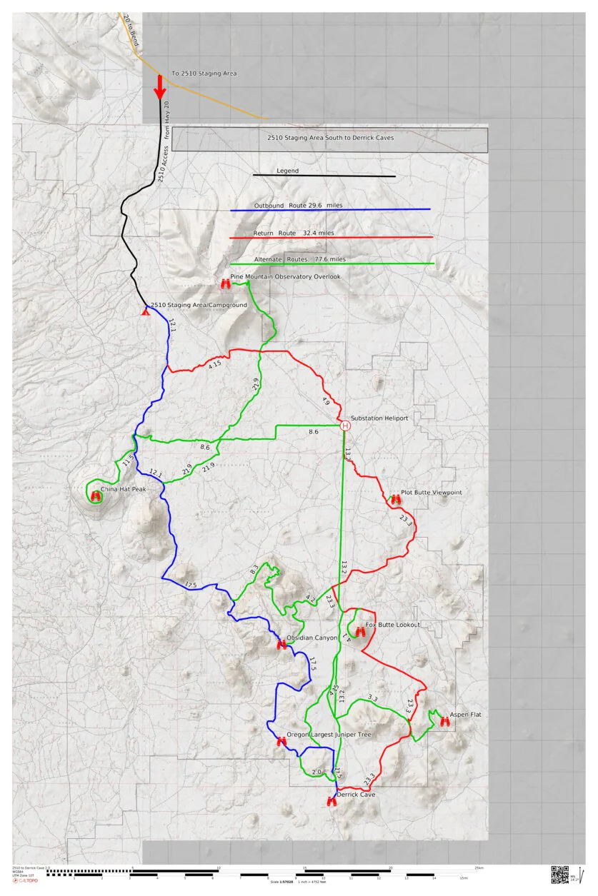
This map is 138 miles of trails south of 2510 Staging Area to Derrick Caves. The map covers 1600 square miles of pines forest east of Newberry National Park with spectacular views from the top of it's many buttes to depths of Derrick Ice Caves. Camping is available at 2510 Staging Area with pit toilets, no water. Access the area by traveling east on Hwy 20 from Bend and then turn right on Forest Service Road 23/25 , 2510 SA is 9 miles. Loo for additional maps that detail rides to Fort Rock for lunch or Crescent Lake for a cool dip in its waters.
Seasonal closes in the area from Nov.30 to April 1 yearly.
Disclaimer; This map is presented for public use as-is, with no guarantee of accuracy or completeness. The geographic information contained on this map is not to be construed or used as a "true description”, conditions are ever changing do to weather, changes in and maintenance of roads and trails and government regulations. Always check with the local authorities before proceeding. Every effort has been made to ensure the map accuracy, but errors in mapping or errors in the source documents do occur. Bronco5Group, llc and/or Oregon SxS Trail Coalition assumes no liability for either any errors, omissions, or inaccuracies in the information provided regardless of their cause, or for any decision made, action taken, or action not taken by the user in reliance upon any maps or information provided. These maps are for information purposes only and may not represent actual conditions.
Product Information
Product Information
Shipping & Returns
Shipping & Returns

Oregon SxS Trail Map 2510 C.G. south to Derrick Caves
Oregon SxS Trail Map 2510 C.G. south to Derrick Caves
This map is 138 miles of trails south of 2510 Staging Area to Derrick Caves. The map covers 1600 square miles of pines forest east of Newberry National Park with spectacular views from the top of it's many buttes to depths of Derrick Ice Caves. Camping is available at 2510 Staging Area with pit toilets, no water. Access the area by traveling east on Hwy 20 from Bend and then turn right on Forest Service Road 23/25 , 2510 SA is 9 miles. Loo for additional maps that detail rides to Fort Rock for lunch or Crescent Lake for a cool dip in its waters.
Seasonal closes in the area from Nov.30 to April 1 yearly.
Disclaimer; This map is presented for public use as-is, with no guarantee of accuracy or completeness. The geographic information contained on this map is not to be construed or used as a "true description”, conditions are ever changing do to weather, changes in and maintenance of roads and trails and government regulations. Always check with the local authorities before proceeding. Every effort has been made to ensure the map accuracy, but errors in mapping or errors in the source documents do occur. Bronco5Group, llc and/or Oregon SxS Trail Coalition assumes no liability for either any errors, omissions, or inaccuracies in the information provided regardless of their cause, or for any decision made, action taken, or action not taken by the user in reliance upon any maps or information provided. These maps are for information purposes only and may not represent actual conditions.
$0.70
Original: $1.99
-65%Oregon SxS Trail Map 2510 C.G. south to Derrick Caves—
$1.99
$0.70Product Information
Product Information
Shipping & Returns
Shipping & Returns
Description
This map is 138 miles of trails south of 2510 Staging Area to Derrick Caves. The map covers 1600 square miles of pines forest east of Newberry National Park with spectacular views from the top of it's many buttes to depths of Derrick Ice Caves. Camping is available at 2510 Staging Area with pit toilets, no water. Access the area by traveling east on Hwy 20 from Bend and then turn right on Forest Service Road 23/25 , 2510 SA is 9 miles. Loo for additional maps that detail rides to Fort Rock for lunch or Crescent Lake for a cool dip in its waters.
Seasonal closes in the area from Nov.30 to April 1 yearly.
Disclaimer; This map is presented for public use as-is, with no guarantee of accuracy or completeness. The geographic information contained on this map is not to be construed or used as a "true description”, conditions are ever changing do to weather, changes in and maintenance of roads and trails and government regulations. Always check with the local authorities before proceeding. Every effort has been made to ensure the map accuracy, but errors in mapping or errors in the source documents do occur. Bronco5Group, llc and/or Oregon SxS Trail Coalition assumes no liability for either any errors, omissions, or inaccuracies in the information provided regardless of their cause, or for any decision made, action taken, or action not taken by the user in reliance upon any maps or information provided. These maps are for information purposes only and may not represent actual conditions.


