🎉 Up to 70% Off Selected ItemsShop Sale
Porcupine Rim - Rated 6
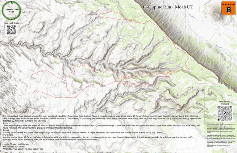
This out-and-back route starts at a spring-fed water tank beside Sand Flats Road, about 9.5 miles from Moab. It drops to a narrow ledge above Negro Bill Canyon, follows upper terraces along the canyon slopes, descends into a small drainage, then ascends rocky terrain to the rim. Lunch is typically at “Picture Rock,” a protruding slab overlooking Castle Valley. The return retraces the same path. The majority of the trail is continuously bumpy.
Scenery
Offers edge-of-canyon views into Negro Bill and Rill Canyons. Along Porcupine Rim (elevations up to 6,800 ft), the overlook drops 1,500 ft to Castle Valley with prominent buttes: Castle Rock, Priest and Nuns, Porcupine Mesa, and Round Mountain. The La Sal Mountains provide a striking southeastern backdrop.
Surface
Primarily bedrock knobs and ledges protruding through the roadbed, with some slickrock sections. At higher elevations, residual snow or mud may be present in early spring (e.g., Easter).
Trail Details
Near the head of Negro Bill Canyon, off-camber ledges test vehicle articulation. Approaching the rim, rocks become larger and more frequent. Between the first and second overlooks, large ledges may slow two-way traffic, especially on the return. Positioning at Picture Rock requires careful maneuvering but yields exceptional views.
Length: 32 total, 6 off highway
Min Tire Size: 33+ inches
Winch: No, Front Locker: No, Rear Locker: Yes
Product Information
Product Information
Shipping & Returns
Shipping & Returns


Porcupine Rim - Rated 6
Porcupine Rim - Rated 6
This out-and-back route starts at a spring-fed water tank beside Sand Flats Road, about 9.5 miles from Moab. It drops to a narrow ledge above Negro Bill Canyon, follows upper terraces along the canyon slopes, descends into a small drainage, then ascends rocky terrain to the rim. Lunch is typically at “Picture Rock,” a protruding slab overlooking Castle Valley. The return retraces the same path. The majority of the trail is continuously bumpy.
Scenery
Offers edge-of-canyon views into Negro Bill and Rill Canyons. Along Porcupine Rim (elevations up to 6,800 ft), the overlook drops 1,500 ft to Castle Valley with prominent buttes: Castle Rock, Priest and Nuns, Porcupine Mesa, and Round Mountain. The La Sal Mountains provide a striking southeastern backdrop.
Surface
Primarily bedrock knobs and ledges protruding through the roadbed, with some slickrock sections. At higher elevations, residual snow or mud may be present in early spring (e.g., Easter).
Trail Details
Near the head of Negro Bill Canyon, off-camber ledges test vehicle articulation. Approaching the rim, rocks become larger and more frequent. Between the first and second overlooks, large ledges may slow two-way traffic, especially on the return. Positioning at Picture Rock requires careful maneuvering but yields exceptional views.
Length: 32 total, 6 off highway
Min Tire Size: 33+ inches
Winch: No, Front Locker: No, Rear Locker: Yes
$0.70
Original: $1.99
-65%Porcupine Rim - Rated 6—
$1.99
$0.70Product Information
Product Information
Shipping & Returns
Shipping & Returns
Description
This out-and-back route starts at a spring-fed water tank beside Sand Flats Road, about 9.5 miles from Moab. It drops to a narrow ledge above Negro Bill Canyon, follows upper terraces along the canyon slopes, descends into a small drainage, then ascends rocky terrain to the rim. Lunch is typically at “Picture Rock,” a protruding slab overlooking Castle Valley. The return retraces the same path. The majority of the trail is continuously bumpy.
Scenery
Offers edge-of-canyon views into Negro Bill and Rill Canyons. Along Porcupine Rim (elevations up to 6,800 ft), the overlook drops 1,500 ft to Castle Valley with prominent buttes: Castle Rock, Priest and Nuns, Porcupine Mesa, and Round Mountain. The La Sal Mountains provide a striking southeastern backdrop.
Surface
Primarily bedrock knobs and ledges protruding through the roadbed, with some slickrock sections. At higher elevations, residual snow or mud may be present in early spring (e.g., Easter).
Trail Details
Near the head of Negro Bill Canyon, off-camber ledges test vehicle articulation. Approaching the rim, rocks become larger and more frequent. Between the first and second overlooks, large ledges may slow two-way traffic, especially on the return. Positioning at Picture Rock requires careful maneuvering but yields exceptional views.
Length: 32 total, 6 off highway
Min Tire Size: 33+ inches
Winch: No, Front Locker: No, Rear Locker: Yes