🎉 Up to 70% Off Selected ItemsShop Sale
Tommy Knocker - Rated 4
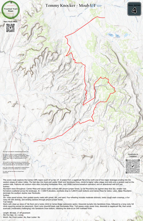
This scenic route explores the Cameo Cliffs region south of La Sal, UT. It enters from a sagebrush flat at the north end of two major drainages eroding into the western slopes of Lisbon Valley. The trail dips into Hook and Ladder Wash and Sandstone Draw, climbs to higher valley edges, and exits onto a graded road on the western side. Features old uranium mine sites (including Homestake Mine, mid-1950s uranium/vanadium operation) and an abandoned well drill pad.
Scenery
Abundant views throughout: Cameo Mesa and canyon walls contrast with pinyon-juniper forest; La Sal Mountains rise against deep blue sky; smaller rock formations scattered across the landscape. At ~7,000 ft elevation, overlooks drop to 5,800-ft wash bottoms and Cameo Mesa far below. Later, Abajo Mountains dominate the southern skyline near Monticello.
Surface
30+ miles paved access, then graded county roads with gravel, dirt, and sand. Four-wheeling includes moderate slickrock, twisty rough wash crossings, a fun rocky hill with shelves, and winding sections through pinyon-juniper forest.
Trail Details
Starts with close-up views of Yak Rock and a twisty climb to Cameo Ridge (panoramic spots). Descends bumpily into Sandstone Draw, followed by a long rocky hill climb requiring precise tire placement. Short rocky downhill leads near Homestake Mine. Trail passes under power lines, descends to sagebrush flat, then winds scenically (moderately challenging) into Sandstone Draw bottom, following the draw to an OHV trailhead finish.
Length: 88 total, 17 off pavement
Min Tire Size: 31+ inches
Winch: No, Front Locker: No, Rear Locker: No
Product Information
Product Information
Shipping & Returns
Shipping & Returns


Tommy Knocker - Rated 4
Tommy Knocker - Rated 4
This scenic route explores the Cameo Cliffs region south of La Sal, UT. It enters from a sagebrush flat at the north end of two major drainages eroding into the western slopes of Lisbon Valley. The trail dips into Hook and Ladder Wash and Sandstone Draw, climbs to higher valley edges, and exits onto a graded road on the western side. Features old uranium mine sites (including Homestake Mine, mid-1950s uranium/vanadium operation) and an abandoned well drill pad.
Scenery
Abundant views throughout: Cameo Mesa and canyon walls contrast with pinyon-juniper forest; La Sal Mountains rise against deep blue sky; smaller rock formations scattered across the landscape. At ~7,000 ft elevation, overlooks drop to 5,800-ft wash bottoms and Cameo Mesa far below. Later, Abajo Mountains dominate the southern skyline near Monticello.
Surface
30+ miles paved access, then graded county roads with gravel, dirt, and sand. Four-wheeling includes moderate slickrock, twisty rough wash crossings, a fun rocky hill with shelves, and winding sections through pinyon-juniper forest.
Trail Details
Starts with close-up views of Yak Rock and a twisty climb to Cameo Ridge (panoramic spots). Descends bumpily into Sandstone Draw, followed by a long rocky hill climb requiring precise tire placement. Short rocky downhill leads near Homestake Mine. Trail passes under power lines, descends to sagebrush flat, then winds scenically (moderately challenging) into Sandstone Draw bottom, following the draw to an OHV trailhead finish.
Length: 88 total, 17 off pavement
Min Tire Size: 31+ inches
Winch: No, Front Locker: No, Rear Locker: No
$1.99
Tommy Knocker - Rated 4—
$1.99
Product Information
Product Information
Shipping & Returns
Shipping & Returns
Description
This scenic route explores the Cameo Cliffs region south of La Sal, UT. It enters from a sagebrush flat at the north end of two major drainages eroding into the western slopes of Lisbon Valley. The trail dips into Hook and Ladder Wash and Sandstone Draw, climbs to higher valley edges, and exits onto a graded road on the western side. Features old uranium mine sites (including Homestake Mine, mid-1950s uranium/vanadium operation) and an abandoned well drill pad.
Scenery
Abundant views throughout: Cameo Mesa and canyon walls contrast with pinyon-juniper forest; La Sal Mountains rise against deep blue sky; smaller rock formations scattered across the landscape. At ~7,000 ft elevation, overlooks drop to 5,800-ft wash bottoms and Cameo Mesa far below. Later, Abajo Mountains dominate the southern skyline near Monticello.
Surface
30+ miles paved access, then graded county roads with gravel, dirt, and sand. Four-wheeling includes moderate slickrock, twisty rough wash crossings, a fun rocky hill with shelves, and winding sections through pinyon-juniper forest.
Trail Details
Starts with close-up views of Yak Rock and a twisty climb to Cameo Ridge (panoramic spots). Descends bumpily into Sandstone Draw, followed by a long rocky hill climb requiring precise tire placement. Short rocky downhill leads near Homestake Mine. Trail passes under power lines, descends to sagebrush flat, then winds scenically (moderately challenging) into Sandstone Draw bottom, following the draw to an OHV trailhead finish.
Length: 88 total, 17 off pavement
Min Tire Size: 31+ inches
Winch: No, Front Locker: No, Rear Locker: No