🎉 Up to 70% Off Selected ItemsShop Sale
Denver West Exploration Map for Sightseeing
This is much more than just a topographic map, road map, trail map, or public lands map, etc... It is all of those things and more! To learn more about our digital maps, view 3D flyover videos, and other stuff we do, check these out!:
https://www.youtube.com/@3dgeologicmappingllc356
https://www.facebook.com/3DGeologicMapping
https://www.3dgeologicmapping.com
To find extremely detailed maps like this one, for your exploring, see our map store for Statewide activity-focus maps, and comprehensive 100K & 250K quadrangle maps https://store.avenza.com/collections/3d-geologic-mapping-llc
or
Download this free index map to get the right one for your area of interest!
https://store.avenza.com/products/index-map-of-100k-quadrangles-for-colorado-3d-geologic-mapping-llc-map-1?utm_source=vendor_link
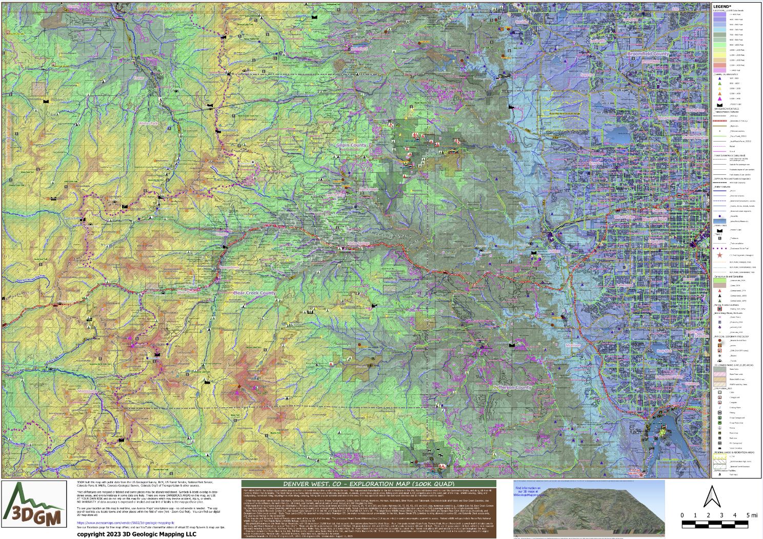
MAP HIGHLIGHTS (as listed in the map's title bar): Recreation opportunities abound within a 5-to-60-minute drive west of Metro Denver. This map extends from Boulder in the NE to Keystone in the SW, from mid-Denver west to over the Continental Divide, and along US Hwy 40 north to Winter Park & Granby. The Front Range mountains, historic mining towns, trailheads, backroads, museums, scenic views, picnic areas, fishing spots and about 1,000 campsites are in the west part of the map. Wildlife-viewing, hiking and backpacking, horseback riding, bicycling/mountain biking, camping, fishing are popular activities and sites in this area. The map spans 53 miles in the east-west direction and 35 miles from north to south.
- Other key mountain towns include Blackhawk, Central City, Empire, Evergreen, Fraser, Georgetown, Golden, Idaho Springs, Keystone, Morrison, Nederland, Silver Plume, and Tabernash. Counties include all of Gilpin and Clear Creek Counties, plus portions of north Jefferson, far north Park Co., SE Grand, east Summit, and small parts of west Denver and NW Douglas Counties.
- Main roads in the mountainous area are Interstates 1-70 (gets very busy during peak times) and C470; US Hwys 6, 36, 40 and 285; and State Highways 36, 72, 85, 93, 105 and 119; plus, numerous paved (e.g., Golden Gate Rd, Deer Creek Canyon Rd, Crawford Gulch Rd, Turkey Creek Rd, and some main county roads) and unpaved county & forest roads. Forest roads are symbolized to show whether a road's intended use is for a 2WD passenger vehicle or for a high-clearance 4WD.
- State Parks include Eldorado Canyon S.P. and Golden Gate Canyon S.P. in the NE, and Staunton S.P. & Chatfield S.P. in the SE. The larger State Wildlife Areas (SWAs) are Mount Evans SWA and Bergen Peak SWA (both in south-central), and Georgetown SWA (west-central). State Trust Lands (STL) for seasonal hunting include Ptarmigan STL (no motor vehicles except snowmobile) in the NW, Beaver Brook STL (primitive hunting allowed) in central-SE, and Bakerville (foot access only, and year-round fishing) in the central-SW.
- The Arapaho and Roosevelt National Forests cover most of the west half of the map. The protected Mount Evans Wilderness Area (116 square miles) in central area requires a permit to access. Federal wildlife refuges include Rocky Flats National Wildlife Refuge and Two Ponds National Wildlife Refuge, both in the NE.
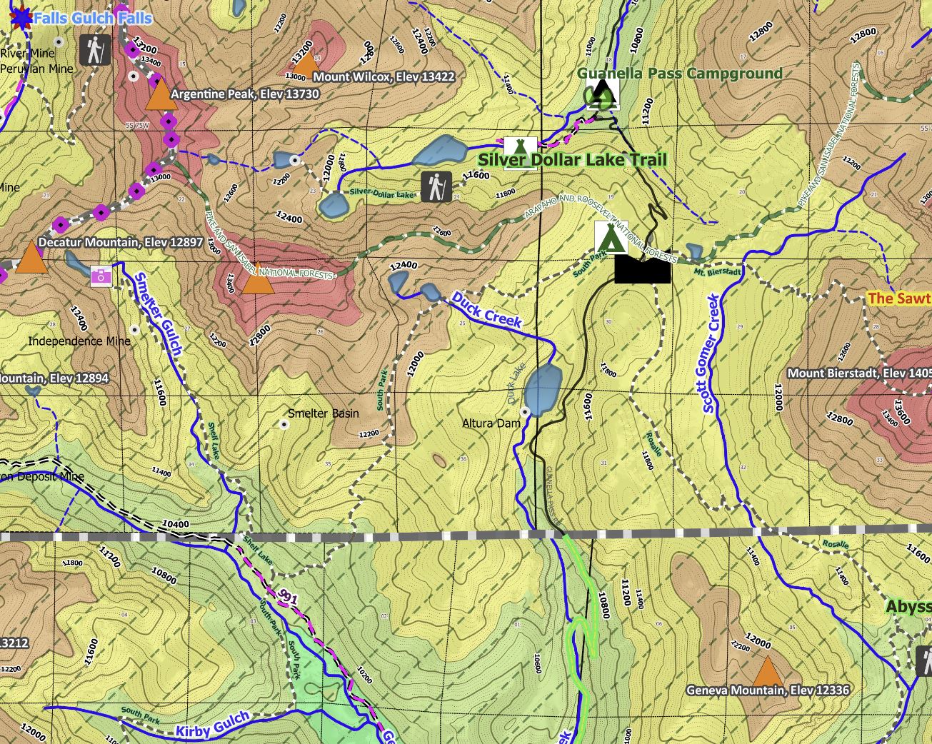
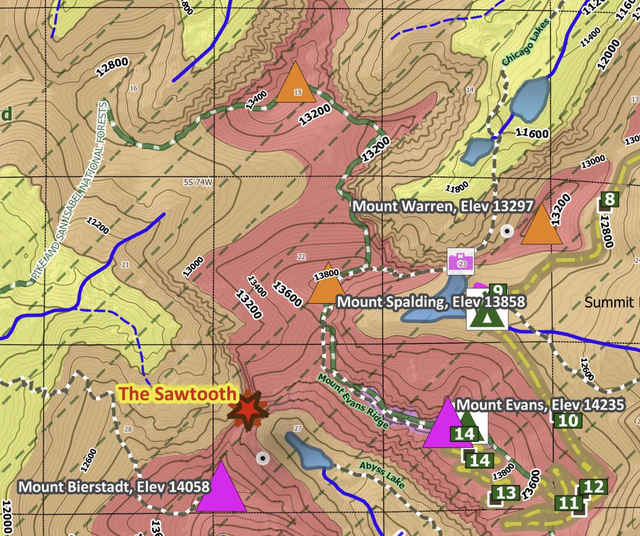
- Key physical features are the Front Range Mountains, with 35 peaks over 13,000 feet tall, that separate the eastern plains from the West Slope. Four 14er peaks include Grays Peak, Torreys Peak, Mount Evans (with a paved road that takes you to the top), and Mount Bierstadt (a popular “first 14er”). There are also 48 peaks between 12K and 13K feet, 30 peaks between 11K and 12K feet, and 40 peaks between 10K and 11K feet. There are 14 passes over 11K feet, with the most traveled (by road) including Loveland Pass, Berthoud Pass, Guanella Pass, Rollins Pass, Squaw Pass, and Juniper Pass. St. Mary’s Glacier has a beautiful lake accessible by a short hike. Scenic rock pillars/cliffs and notable tunnels occur throughout the map.
- Main rivers include the Fraser River in the NW, Fall River in the central area, Snake River in the SW, and South Platte River in the SE. There are about 200 named lakes and reservoir in the vicinity, with most in the eastern plains area; the largest include Standley Lake, Morston Lake, Chatfield Reservoir, Gross Reservoir, and Baseline Reservoir.
- Coordinate bounds are 39.5 to 40 degrees LAT, 105 to 106 degrees LON. Version date: August 11, 2023
Other map features you'll like include labeled 1-mile sections that allow for easy distance estimates, highway mile markers, and notable amenities on public lands (picnic areas, restrooms).
Easily see elevation changes and recreation places of interest! The Avenza Maps smartphone app lets you see your location as you move around in the map area (without needing cell service), set a location pin to find your way back to your car or campsite, track your path in real-time, and more!
Product Information
Product Information
Shipping & Returns
Shipping & Returns
Denver West Exploration Map for Sightseeing
Denver West Exploration Map for Sightseeing
This is much more than just a topographic map, road map, trail map, or public lands map, etc... It is all of those things and more! To learn more about our digital maps, view 3D flyover videos, and other stuff we do, check these out!:
https://www.youtube.com/@3dgeologicmappingllc356
https://www.facebook.com/3DGeologicMapping
https://www.3dgeologicmapping.com
To find extremely detailed maps like this one, for your exploring, see our map store for Statewide activity-focus maps, and comprehensive 100K & 250K quadrangle maps https://store.avenza.com/collections/3d-geologic-mapping-llc
or
Download this free index map to get the right one for your area of interest!
https://store.avenza.com/products/index-map-of-100k-quadrangles-for-colorado-3d-geologic-mapping-llc-map-1?utm_source=vendor_link
MAP HIGHLIGHTS (as listed in the map's title bar): Recreation opportunities abound within a 5-to-60-minute drive west of Metro Denver. This map extends from Boulder in the NE to Keystone in the SW, from mid-Denver west to over the Continental Divide, and along US Hwy 40 north to Winter Park & Granby. The Front Range mountains, historic mining towns, trailheads, backroads, museums, scenic views, picnic areas, fishing spots and about 1,000 campsites are in the west part of the map. Wildlife-viewing, hiking and backpacking, horseback riding, bicycling/mountain biking, camping, fishing are popular activities and sites in this area. The map spans 53 miles in the east-west direction and 35 miles from north to south.
- Other key mountain towns include Blackhawk, Central City, Empire, Evergreen, Fraser, Georgetown, Golden, Idaho Springs, Keystone, Morrison, Nederland, Silver Plume, and Tabernash. Counties include all of Gilpin and Clear Creek Counties, plus portions of north Jefferson, far north Park Co., SE Grand, east Summit, and small parts of west Denver and NW Douglas Counties.
- Main roads in the mountainous area are Interstates 1-70 (gets very busy during peak times) and C470; US Hwys 6, 36, 40 and 285; and State Highways 36, 72, 85, 93, 105 and 119; plus, numerous paved (e.g., Golden Gate Rd, Deer Creek Canyon Rd, Crawford Gulch Rd, Turkey Creek Rd, and some main county roads) and unpaved county & forest roads. Forest roads are symbolized to show whether a road's intended use is for a 2WD passenger vehicle or for a high-clearance 4WD.
- State Parks include Eldorado Canyon S.P. and Golden Gate Canyon S.P. in the NE, and Staunton S.P. & Chatfield S.P. in the SE. The larger State Wildlife Areas (SWAs) are Mount Evans SWA and Bergen Peak SWA (both in south-central), and Georgetown SWA (west-central). State Trust Lands (STL) for seasonal hunting include Ptarmigan STL (no motor vehicles except snowmobile) in the NW, Beaver Brook STL (primitive hunting allowed) in central-SE, and Bakerville (foot access only, and year-round fishing) in the central-SW.
- The Arapaho and Roosevelt National Forests cover most of the west half of the map. The protected Mount Evans Wilderness Area (116 square miles) in central area requires a permit to access. Federal wildlife refuges include Rocky Flats National Wildlife Refuge and Two Ponds National Wildlife Refuge, both in the NE.
- Key physical features are the Front Range Mountains, with 35 peaks over 13,000 feet tall, that separate the eastern plains from the West Slope. Four 14er peaks include Grays Peak, Torreys Peak, Mount Evans (with a paved road that takes you to the top), and Mount Bierstadt (a popular “first 14er”). There are also 48 peaks between 12K and 13K feet, 30 peaks between 11K and 12K feet, and 40 peaks between 10K and 11K feet. There are 14 passes over 11K feet, with the most traveled (by road) including Loveland Pass, Berthoud Pass, Guanella Pass, Rollins Pass, Squaw Pass, and Juniper Pass. St. Mary’s Glacier has a beautiful lake accessible by a short hike. Scenic rock pillars/cliffs and notable tunnels occur throughout the map.
- Main rivers include the Fraser River in the NW, Fall River in the central area, Snake River in the SW, and South Platte River in the SE. There are about 200 named lakes and reservoir in the vicinity, with most in the eastern plains area; the largest include Standley Lake, Morston Lake, Chatfield Reservoir, Gross Reservoir, and Baseline Reservoir.
- Coordinate bounds are 39.5 to 40 degrees LAT, 105 to 106 degrees LON. Version date: August 11, 2023
Other map features you'll like include labeled 1-mile sections that allow for easy distance estimates, highway mile markers, and notable amenities on public lands (picnic areas, restrooms).
Easily see elevation changes and recreation places of interest! The Avenza Maps smartphone app lets you see your location as you move around in the map area (without needing cell service), set a location pin to find your way back to your car or campsite, track your path in real-time, and more!
$4.99
Denver West Exploration Map for Sightseeing—
$4.99
Product Information
Product Information
Shipping & Returns
Shipping & Returns
Description
This is much more than just a topographic map, road map, trail map, or public lands map, etc... It is all of those things and more! To learn more about our digital maps, view 3D flyover videos, and other stuff we do, check these out!:
https://www.youtube.com/@3dgeologicmappingllc356
https://www.facebook.com/3DGeologicMapping
https://www.3dgeologicmapping.com
To find extremely detailed maps like this one, for your exploring, see our map store for Statewide activity-focus maps, and comprehensive 100K & 250K quadrangle maps https://store.avenza.com/collections/3d-geologic-mapping-llc
or
Download this free index map to get the right one for your area of interest!
https://store.avenza.com/products/index-map-of-100k-quadrangles-for-colorado-3d-geologic-mapping-llc-map-1?utm_source=vendor_link
MAP HIGHLIGHTS (as listed in the map's title bar): Recreation opportunities abound within a 5-to-60-minute drive west of Metro Denver. This map extends from Boulder in the NE to Keystone in the SW, from mid-Denver west to over the Continental Divide, and along US Hwy 40 north to Winter Park & Granby. The Front Range mountains, historic mining towns, trailheads, backroads, museums, scenic views, picnic areas, fishing spots and about 1,000 campsites are in the west part of the map. Wildlife-viewing, hiking and backpacking, horseback riding, bicycling/mountain biking, camping, fishing are popular activities and sites in this area. The map spans 53 miles in the east-west direction and 35 miles from north to south.
- Other key mountain towns include Blackhawk, Central City, Empire, Evergreen, Fraser, Georgetown, Golden, Idaho Springs, Keystone, Morrison, Nederland, Silver Plume, and Tabernash. Counties include all of Gilpin and Clear Creek Counties, plus portions of north Jefferson, far north Park Co., SE Grand, east Summit, and small parts of west Denver and NW Douglas Counties.
- Main roads in the mountainous area are Interstates 1-70 (gets very busy during peak times) and C470; US Hwys 6, 36, 40 and 285; and State Highways 36, 72, 85, 93, 105 and 119; plus, numerous paved (e.g., Golden Gate Rd, Deer Creek Canyon Rd, Crawford Gulch Rd, Turkey Creek Rd, and some main county roads) and unpaved county & forest roads. Forest roads are symbolized to show whether a road's intended use is for a 2WD passenger vehicle or for a high-clearance 4WD.
- State Parks include Eldorado Canyon S.P. and Golden Gate Canyon S.P. in the NE, and Staunton S.P. & Chatfield S.P. in the SE. The larger State Wildlife Areas (SWAs) are Mount Evans SWA and Bergen Peak SWA (both in south-central), and Georgetown SWA (west-central). State Trust Lands (STL) for seasonal hunting include Ptarmigan STL (no motor vehicles except snowmobile) in the NW, Beaver Brook STL (primitive hunting allowed) in central-SE, and Bakerville (foot access only, and year-round fishing) in the central-SW.
- The Arapaho and Roosevelt National Forests cover most of the west half of the map. The protected Mount Evans Wilderness Area (116 square miles) in central area requires a permit to access. Federal wildlife refuges include Rocky Flats National Wildlife Refuge and Two Ponds National Wildlife Refuge, both in the NE.
- Key physical features are the Front Range Mountains, with 35 peaks over 13,000 feet tall, that separate the eastern plains from the West Slope. Four 14er peaks include Grays Peak, Torreys Peak, Mount Evans (with a paved road that takes you to the top), and Mount Bierstadt (a popular “first 14er”). There are also 48 peaks between 12K and 13K feet, 30 peaks between 11K and 12K feet, and 40 peaks between 10K and 11K feet. There are 14 passes over 11K feet, with the most traveled (by road) including Loveland Pass, Berthoud Pass, Guanella Pass, Rollins Pass, Squaw Pass, and Juniper Pass. St. Mary’s Glacier has a beautiful lake accessible by a short hike. Scenic rock pillars/cliffs and notable tunnels occur throughout the map.
- Main rivers include the Fraser River in the NW, Fall River in the central area, Snake River in the SW, and South Platte River in the SE. There are about 200 named lakes and reservoir in the vicinity, with most in the eastern plains area; the largest include Standley Lake, Morston Lake, Chatfield Reservoir, Gross Reservoir, and Baseline Reservoir.
- Coordinate bounds are 39.5 to 40 degrees LAT, 105 to 106 degrees LON. Version date: August 11, 2023
Other map features you'll like include labeled 1-mile sections that allow for easy distance estimates, highway mile markers, and notable amenities on public lands (picnic areas, restrooms).
Easily see elevation changes and recreation places of interest! The Avenza Maps smartphone app lets you see your location as you move around in the map area (without needing cell service), set a location pin to find your way back to your car or campsite, track your path in real-time, and more!